Before we left Oamaru, we had to buy a new bucket for David to use when he empties the grey water tank - instead of having me park near the dumpstation and using the hose, David prefers to empty the tank manually almost every day, using a bucket. Don't ask me why except that it means we don't have to move the motorhome when the tank has water in it when we are not heading away anywhere. However David had commandeered my collapsible silicone bucket for decanting the contents of the tank into the dumpstation. I had bought the bucket way back when we first bought the motorhome and it had been used often for putting small bits of laundry (mine, not his) in - I fill it with water, add soap powder and place it in the shower tray and then the laundry gets jiggled around as we travel along and is pretty clean by the time we reach our destination. All that's left to do is rinse, wring out and hang up. I always left the bucket in its extended position. However once waste-man got hold of it, it kept being extended/contracted/extended almost every day - did I tell you that waste-man likes to make sure the tank is always emptied? And did I tell you that he keeps the bucket in the garage and it needs to be contracted so it doesn't take up much room? So, the inevitable happens - the folds weaken through excessive use, and splits occur. Hence new bucket required, dammit... So a trip to Mitre 10 and then a grocery top up at New World before we headed away.
Not far out of Oamaru, on SH 83 were parts of the Vanished World that we had read about at Moeraki on the DOC interp there - so we had a stop at Duntroon both for lunch and for seeing just a bit of what was there. In the information centre was a raft of history, artefacts and models of what had been in and around the area - check out the link here: Vanished World It is clear to me from looking at that link, that David and I need to go back again and spend much more than a couple of hours in the area! I foresee at least a couple of full days exploring.
 |
If
you compare David's height and the height of the fully grown pines
above with the caves in the rock cliff, even allowing for distance and
perspective, you can see that the caves are quite substantial.
|
 |
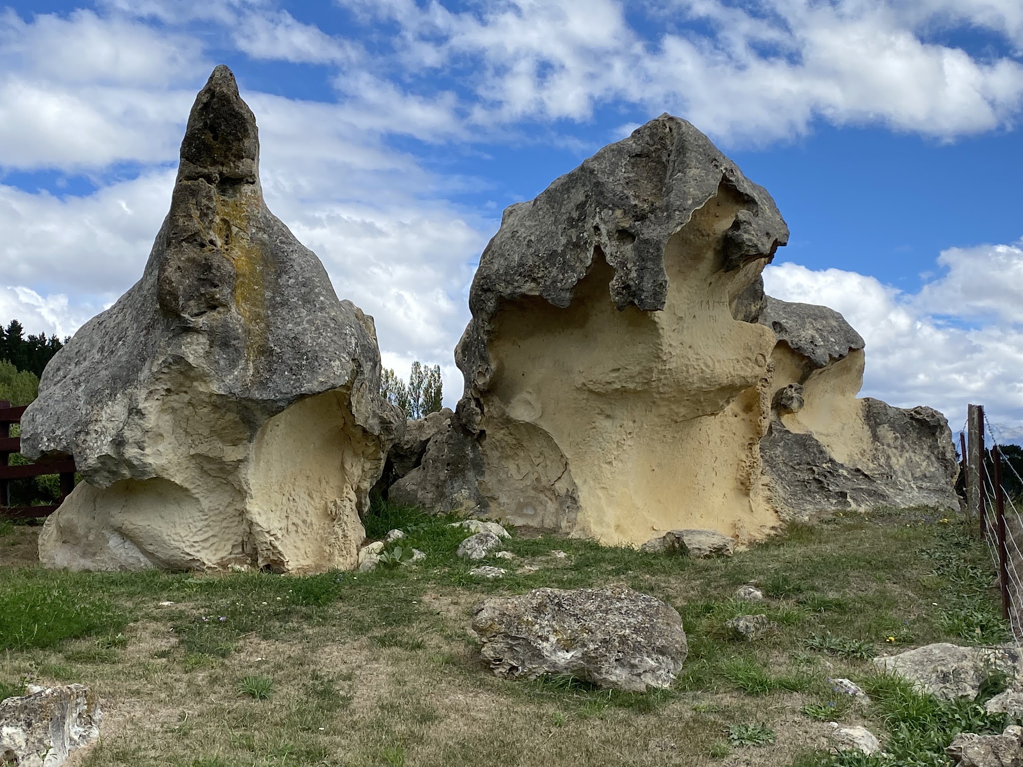
Because some people cannot help but vandalise or steal, the rock drawings are now separated from the public by sturdy metal caging. There is signage to explain what the drawings represented - apparently they represent people and taniwha, mythical water creatures.
|
 |
The real thing - I can see people being pursued by taniwha, I think.
|
 |
Wind and weather have done their work on the cliff.
|
 |
It was a bit spooky walking underneath this ...
|
 |
I
am a bit paranoid about overhanging rocks etc, and just to prove that
rockfalls do happen, here's one that nature prepared earlier ...
|
 |
The fencing around the site has been built using Maori methods and materials. The pole at the right is a pou, a land post.
|
 |
These distinctive rock formations show the dramatic effects of weather
|
There is more and better information here about the Maori rock drawings that we went to see: https://www.heritage.org.nz/the-list/details/5653 - I'm not so good on describing the historical aspects, so it's best I provide you with links instead.
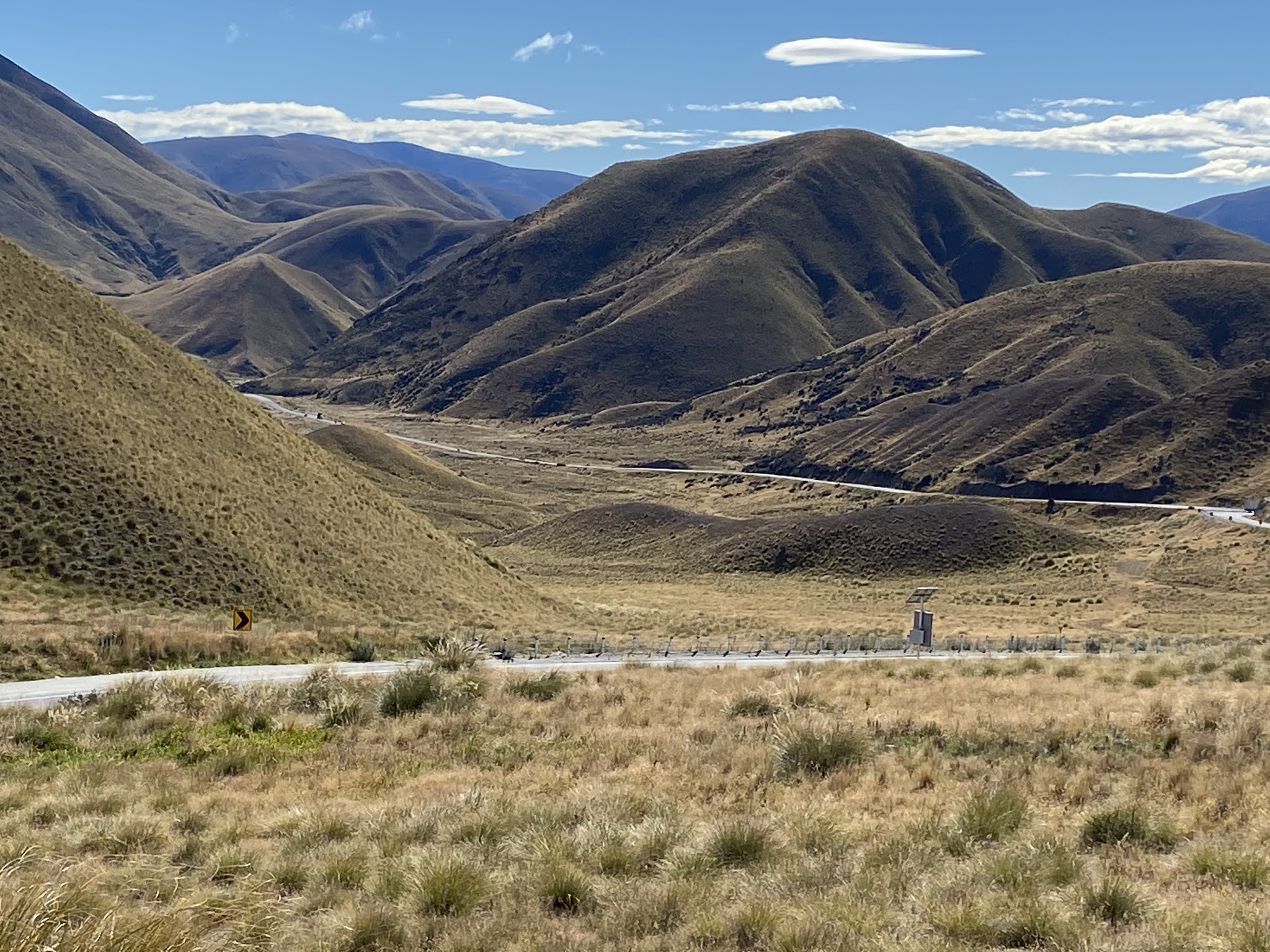
The geographic nature of the countryside changes dramatically once the coast is left behind. The braided Waitaki River with wide river flats, a lake dammed to create the Aviemore Power Station, and ranges and mountains in the distance.
 |
| We stopped just off the side of the road to see the Aviemore Dam and the artefacts - this baby weighs 17 tonnes! It is a turbine runner and was first used to drive one of the generators at the Waitaki Power Station in 1941. It is made of cast steel and was manufactured in the UK. It has NOT come from this power station which was built in 1962. |
 |
Looking towards the dam with the Aviemore powerhouse building to the right
|
Read more about Aviemore here Its turbines and output are ENORMOUS!!
At Omarama, we turned on to SH 8, and aimed for the Longslip Station camping area which is only open to NZMCA members. I had decided I had to overcome my fear of camping out in the wilds and Longslip Station was obviously the place to do it. On arrival we had to go through the gate that has a coded padlock and it then had to be locked behind us. As I drive, David has to do any gate duty - it seems only fair ...
 |
Here he is opening the gate for me to drive through.
|
 |
And here he is closing the gate after I have gone through it.
|
I took the second photo of the view from the rear view camera.
What is wrong with what is happening - remembering I have already driven
through the gate??? Sometimes I do wonder what goes on in his mind ... I am pleased that the photo is as clear as it is because I was laughing very loudly! So loudly that I didn't watch him climb over the fence.
Fast forward to the next morning - remember I said I had decided to overcome my fear of freedom camping in the wilds and this was the place to do it because the gate was locked? Well, no it wasn't: David discovered as we left the site that he hadn't closed the hasp. So not only needn't he have climbed over the fence, but I shouldn't have felt so secure ...
It was such a beautiful place to be - the wind came up, and as we had parked facing the mountain range in front of us, we were able to watch the clouds and the rain roll in early in the evening and felt very snug and warm.
 |
There we are in splendid isolation with mountain ranges in front of us, the river off to our right, and hills on either side
|
 |
We were a little early for the lupins to be in full bloom, but they were on their way. The clouds were approaching by the minute and the wind was rising.
|
 |
The white rocks are the demarcation of the campsite - you can see there is plenty of room. The owners have placed a limit of 10 vehicles at a time - even if that limit was reached the sense of privacy and space would not be breached.
|
And we felt smug about being as snug as a bug in a rug with the quite wild weather outside - until about 4am when the alarm went off indicating that the leisure battery was low. Not a good idea apparently to leave phones and laptops charging overnight using the little inverter when there's no solar power being generated (darkness ...) and we weren't hooked up to the national grid. That meant we could not turn on the gas heating because it needs battery power to fire it up, dammit. Fortunately the electric striker on the stovetop was able to work otherwise the technical manager may have been in very deep trouble if no tea could be brewed in the morning! Matches were a rapid addition to the shopping list and a new rule instituted that no charging or use of the little inverter when not on power. We think though that we may need a new battery, an additional battery as well as an additional solar panel.
The weather had cleared overnight and it got quite a lot colder, and in the morning we woke to a fabulous cloudless blue sky.
 |
A chilly morning at Longslip Station in early March!
|
 |
But look at that sky and that mountain that was covered with cloud the night before!
|
 |
A wider view up the valley with the sun and shade on the contours of the hills
|
 |
Recycle and reuse: the old fridge used as a book exchange and a visitor registration office. Complete with instructions on how to pay online as some miserable thieves had previously cleaned out the cash box - bastards.
|
The sunny weather that day was perfect for our drive up to and over the Lindis Pass. What an amazing piece of road in stunning scenery. I am always struck by the forethought that goes into the planning and engineering - not only is the road wide and in excellent condition, there are rest areas for people to pull over into to be able to get out, walk to a viewing area and see the countryside in safety. And there's also quite a number of places wide enough for motorhomers to pull over and let faster traffic pass - always a kindness, I think.
 |
The road ahead of us
|
 |
And the road behind.
|
 |
These flowers made me think of Lisa from nb What a Life because she posts pictures of what she calls pretties. And I was very impressed with this high country bee toiling away!
|
 |
Now in to tussock country
|
Once through the Lindis Pass, travelling to Wanaka does require careful
map reading or assiduous following of the signs - the whole area is
mountainous so the roads follow the valleys. And while you might think that places on the map look
quite close by as those pesky crows fly, they actually require quite long journeys.
Next time, we will spend more time exploring those other byways and
highways because it is such a beautiful area to be.
 |
The blue marks our route, the white are the mountains and the green shows the high country - it's pretty much all mountain ranges! No wonder the place is such a magnet for tourists!
|
We do like Wanaka - it is touristy but not over the top like Queenstown. Of course, no tourists were present while we were travelling around this time. While I recognise that is a bummer for tourism operators, it is a boon for NZers who can often feel overwhelmed because we are not really comfortable with large numbers of people around us, to be honest.
 |
We stayed at the Mt Aspiring Holiday Park on the outskirts of Wanaka (on the way to Glendhu). It was just wonderful. This is the view from our site.
|
 |
And the view when we stepped a few paces to the left. Look at those amazing ranges and how the light falls on them!
|
Bliss!


3 comments:
Such interesting things to see in Duntroon, but I see no mention of Elephant Rocks which are close by? Did you visit them as well?
The South Island certainly has spectacular scenery.
Jenny, we didn't find them - we clearly didn't take in the instructions properly from the person who gave them on where they were. Next time, we will use a map! And be in less of a hurry which would help!
Cheers, M
Fabulous views and have you found the Italian restaurant in Wanaka yet?
Lisa
NM WaL
Post a Comment