It is a very LONG time since I posted and I don't have any excuses. While the text in this post is not very long by my standards, I have included heaps of photos. My apologies - this blog is for the readers, and as well as that (and as important) is that it's a record of now for the future. At the moment, our grandkids don't read it, David doesn't read it. I know our daughter does, but I am fairly sure our son doesn't. But at some time in the future, they will want to so they can find out more about who we were and what we did.
So as I said, my apologies if this is exceedingly long - please just scroll on through quickly if it's a bit boring!
However, I'd suggest that you use the photos of the stunning part of the country as a travel brochure - of a country you plan to visit as soon as Covid-19 releases its hold on us all...
When we left Marahau in Golden Bay back in mid February, we knew we had to put in some miles if we were to get around this island in any reasonable time! So our next stop was Murchison, which feels like, even if it isn't officially, the entrance to the West Coast. I think it's to do with the topography and geology of the area.
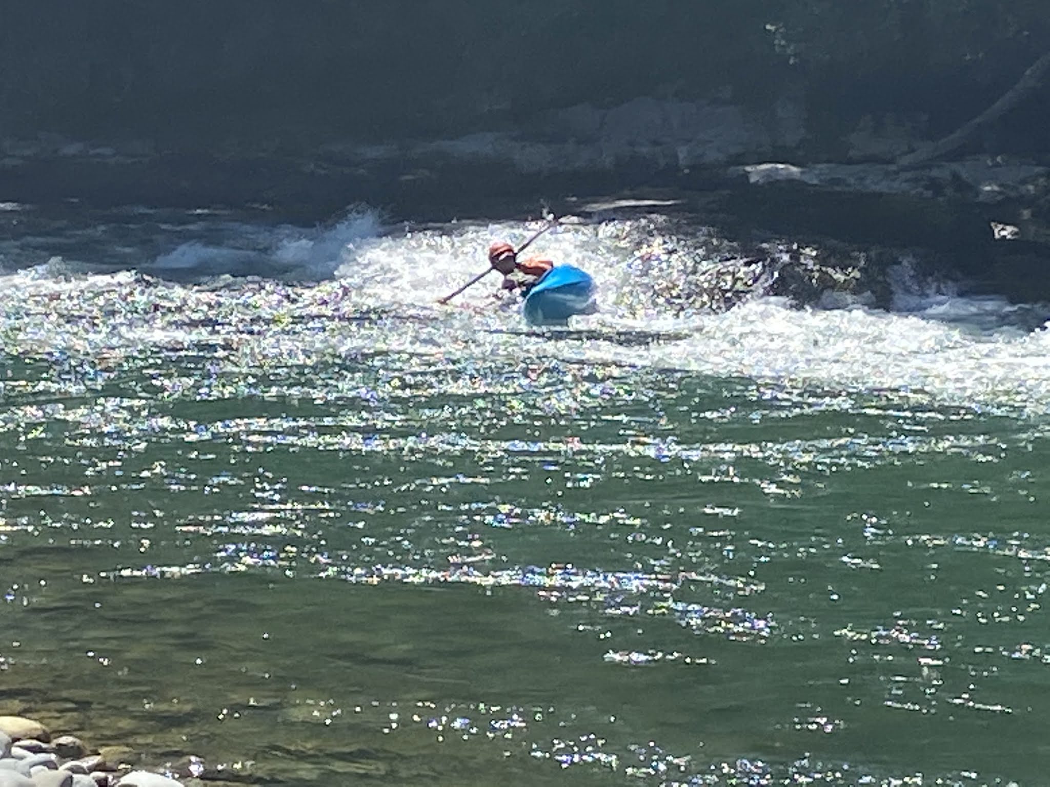
We stayed two days at Murchison Motorcamp - a wonderful place that is about 8kms short of the town. And we just blobbed and juiced and walked down to the river and went for a walk along a made path on the property and sat in the sun reading and caught up on washing. And took photos. And watched a group of kayakers playing in the rapids on the river. And we didn't feel the need to do anything more strenuous. It is a holiday, after all.
 |
Most sites have a wee hedge or a tree planted between them. I reckon this photo was taken early in the morning - so probably by David ...
|
 |
Part of the grounds - tent sites are closer to the river and the hills to the east. Karen did say the occupancy was down 52% because of COVID-19, and there were only a few motorhomes in while we were there.
|
 |
And the hills to the north, whence we came ...
|
 |
Down by the river - the little set of rapids near the trees
|
 |
I am upright here, but boy, was that surface hard to walk on steadily!
|
 |
And down river. Look at the blue of the sky!
|
 |
Very rocky beach - not easy to walk over. Can you see the kayakers on the left just coming around the bend in the river?
|
 |
Into the rapids
|
 |
And through them
|
 |
And the next one comes through
|
 |
And the first one goes back through again - a lot of playing!
|
 |
And there were inquisitive chooks - David was pleased because it meant there was an appreciative group waiting for the detritus from his juicing. I was pleased because I do like vege scraps to go to something further down the food chain!
|
 |
In the evening we walked down to a different part of the beach - a bit of a tricky route down and back, so it is rope-assisted. Reminded me of the track our kids used to go down to the beach at Rowles' Bend in Tongaporutu - but that was a much steeper and longer path, however they are much younger than us ...
|
 |
In case we weren't sure ...
|
 |
In case you think David has an easy life, here he is mopping the floor by hand on his knees. See, he really does SUFFER!
|
 |
Barry the cat was lurking in case there was any lunch for him to share. Karen has constructed a covered verandah all around the kitchen dining area - covered to keep out the wind, rain and sandflies which are ubiquitous here.
|
We will definitely go back there - it is a very welcoming and peaceful place, beautifully set out with a great eye for detail and for what works for its visitors. Karen who owns and runs it, designed and developed the whole place, and the garden and landscaping have been designed and developed by her and her mum.
The only flaw on our way between Marahau and Murchison was that the rear vision camera cut out occasionally - it had done so on our way into Takaka, and David had changed the fuse which seemed to fix it. But then it started cutting out frequently. It is disconcerting to suddenly look at it for a view of what is coming along behind and find that the screen is BLANK! I have very good wing mirrors but they don't show me what is right behind me - and cannot do so given the width of the vehicle and the position of the mirrors. What we did find out fortunately was that if I stopped (at a safe place with enough space for me to pull off the road) and turned off the engine, the camera would reactivate when the engine started up again. Weird, or what?
We tried to find an auto-electrician in Westport, but the only one there was booked up till about Easter - no use to us. So we decided that because we could get it to start up again, we would book in with an auto-electrician in Greymouth who could see us on the Friday, which was a few days ahead - hence the blobbing in Murchison.
It was many years since we had visited Punakaiki, even though I had worked down on the West Coast and David had visited - we had never made the trip there. We had been past a few times but not stopped. So this time, from Murchison we headed through the Upper and Lower Buller Gorge (a fabulous trip on the most amazing road built with grit and muscle and sheer hard work!) out to Westport.
 |
The Buller Gorge is heavily forested in native trees, and follows the Buller River
|
 |
Not a very good photo, I'm sorry, but it contains significant information. The journey between Nelson and Paringa is 562 kilometres (about 350 miles) and now takes just over 7 hours to drive. So 1124 kms (700 miles) and 14 hours to drive. Almost all the way, it is very challenging terrain and is mostly through mountain passes and along river gorges, and through thick bush all the way - apart from some short distances where it goes through river flats and swampy areas close to the sea. As I say: very challenging! So I am not surprised by the 550 days for a return journey.
|
 |
The road through the Buller Gorge is spectacular - an amazing feat of engineering. There are a number of one way bridges - there are many of these on the West Coast - and I like to drive over them slowly so David can take photos. Of course, being high up in the motorhome means there are great views.
|
 |
This is Hawk's Crag where the road has been carved from the cliff with enough height for large trucks to go through easily. It's one lane only, so there's time to contemplate it before you go through. I took this photo from a rest area/viewing area just before it. I remember the first time I drove the motorhome through, I ducked my head - nuts, I know, but even though I KNEW there was plenty of headroom, it felt very close ...
|
We had wanted to catch up with Leonie in Westport but she was heading away to Karamea and we would just miss her. So we had a bite to eat in the town, did the grocery shopping, swapped an empty gas bottle for a full one, and headed on down the coast on yet another amazing road to Punakaiki.
Yet again we were both so admiring of the work that the Dept of Conservation has done in developing the site at Punakaiki, aka the Pancake Rocks. The segregated parking to make sure cars and motorhomes do not get in each other's way; the buildings, both the DOC info centre and the commercial activities across the road from the sea. The paths, the decking, the bridges are all top notch in quality. The signage is informative and interesting and very comprehensive. And the track meanders through the coastal bush, with no straight lines but in sympathy with the trees and ferns and flaxes. And you can hear the birdlife as you walk. It is lovely.
And then you come to the rocks and cliffs. It is just magic - or as Sam Neill's character in Hunt for the Wilderpeople said, it's majestical.
The immense power of the sea is on display in the way the waves muscle their way through the gaps in the cliffs and pound against those still standing. It is awe-inspiring.
 |
Nikau palms and flaxes alongside other trees that grow so prolifically along this coast.
|
 |
The sea is exceedingly powerful and has caused the many little islands/rock formations
|
 |
The nature of the rock in strata is exacerbated by the constant pounding of wind and sea
|
 |
The sea has forced its way through and formed an open-topped cavern
|
 |
| On the other side of the cavern, the waves have rushed through and smash against the opposite wall. | |
|
 |
These two shots show the detail of the sea's work - all the way to the tops of the cliffs
|
 |
This is why they are called the Pancake Rocks - they look like stacks of oddly shaped pikelets to me!
|
 |
The viewing platform and the view south along the coast. I would love to know why these rock formations occur here and nowhere else on this coast. I sense a bit of research coming on ...
|
 |
And still people do climb over it ...
|
 |
On Sandra and Barry's blog nb Are and Are they had a fabulous photo of a koru - this is my attempt! Not as good by any stretch though!
|
We headed back to Punakaiki village to the motorcamp there and set up in a very nice spot - but soon had to move. AAARRRGGGHHH!!! Right behind us was a building that was currently housing about 30 7 - 9 year old kids on school camp. AAARRRGGGHHH!!! They were NOISY. They were constantly shouting and shrieking, and the noise went right through me. So I asked at the office if we could move somewhere less screechy. The new site wasn't so pretty but it was quiet ...
 |
Our original spot - you cannot see the house behind housing VERY noisy kids...
|
 |
On the beach right beside the camp, looking north
|
 |
and south towards Punakaiki where we had just been that afternoon.
|
 |
Still not sunset ...
|
 |
Happiness is sitting on a bench on the beach in the setting (eventually) sun.
|
And we were leaving quite early in the morning to head to Greymouth to see the auto-electrician, so an early night was definitely called for and there would not have been an early night with 30 kids right behind us! I don't think any of the kids would have been asleep much before midnight - it was school camp after all and staying awake late is a rule, I reckon! However I did have an early night - so early that I didn't even stay awake to go back and see the sunset from the beach beside us.
We left the motorhome with the auto-electricians by about 8am the next day, and then walked to Blanchard's Bakery to have brekkie. We have found that cafes here are very accommodating about David's dietary needs and Blanchard's was no different. Lovely food and excellent and friendly service. It's one of my favourite bakeries ever because of the range of food, and that it is retro without meaning to be - it's just the way it has always been. So it is a nostalgic place to go.
As we were leaving, David got stopped by a guy at one of the tables who recognised him from when we were staying in Hokitika last year while I was working at DOC for the 6 - 7 weeks. David had been out on one of the Hokitika Hikers walks with my boss's wife, and this man is a regular and had been on the same walk. So a long chat with him and his friend ensued. They have both been involved with the development of the Pike 29 Memorial Walk from the Maori perspective, so it was interesting to listen to them talking about what it means to the local runanga and iwi.
We took a walk across the Cobden bridge to check out the river bank down towards the mouth, then back over the river and along the built up river wall - it borders the town and because of frequent flooding, the banks are very high. It is amazing to see the river when it is placid and gentle and low, and then see it as a raging torrent when the heavy rain that has fallen in the hills sweeps down into the river upstream, bringing logs and debris that catch on the stanchions of the bridges. At those times the high build of the wall doesn't look quite so high!
The auto-electrician had done a search along the wiring where it was visible but had not been able to replicate the fault. Since then, of course, it hasn't happened again - that could be because we haven't travelled over such rough roads and so the connections haven't been stressed. Who knows?
We had decided that we would have a quiet weekend in Greymouth and had chatted with a guy on our walk who said it was great down by the rivermouth on the northern side. We went to have a look but at just after noon it was already jam packed with motorhomes and caravans and campers. Not for us! So we headed a few kilometres away to the Top 10 - it is on the south side of the town and very close to the beach - as everything is in Greymouth ...
It was peaceful, sunny, well-equipped and clean. And we had shade.
 |
My view as I wrote the last blog post. Beyond those shrubs is the cycleway and then the beach - next stop Australia!
|
 |
David took this photo - he thought it worthy of note.
|
If I remember correctly, we blobbed a lot. David did juicing and happily fed the chooks. I think I wrote the last post there, and that was weeks ago ...


2 comments:
So nice to read about your SI trip and revisit through your eyes that spectacular scenery. Wondering about your future plans? Take care, drive safely, and keep blogging!
The need to move and travel I commend you fab to follow your blog nb cassita wAs based in debdale UK however due to lockdown our boat has been moored top of foxton locks with no access due to local restrictions
Post a Comment